
A lake lap for an easy morning. A forest circuit for a change of scene. Two parks when there is time to go further. Benjakitti offers more than one way to run, and choosing the shape of your outing is a better place to start than choosing a round number.
Select a route above to highlight its path. The distance plans sit separately: running farther around the same circuit does not create a different route.
The lake lap
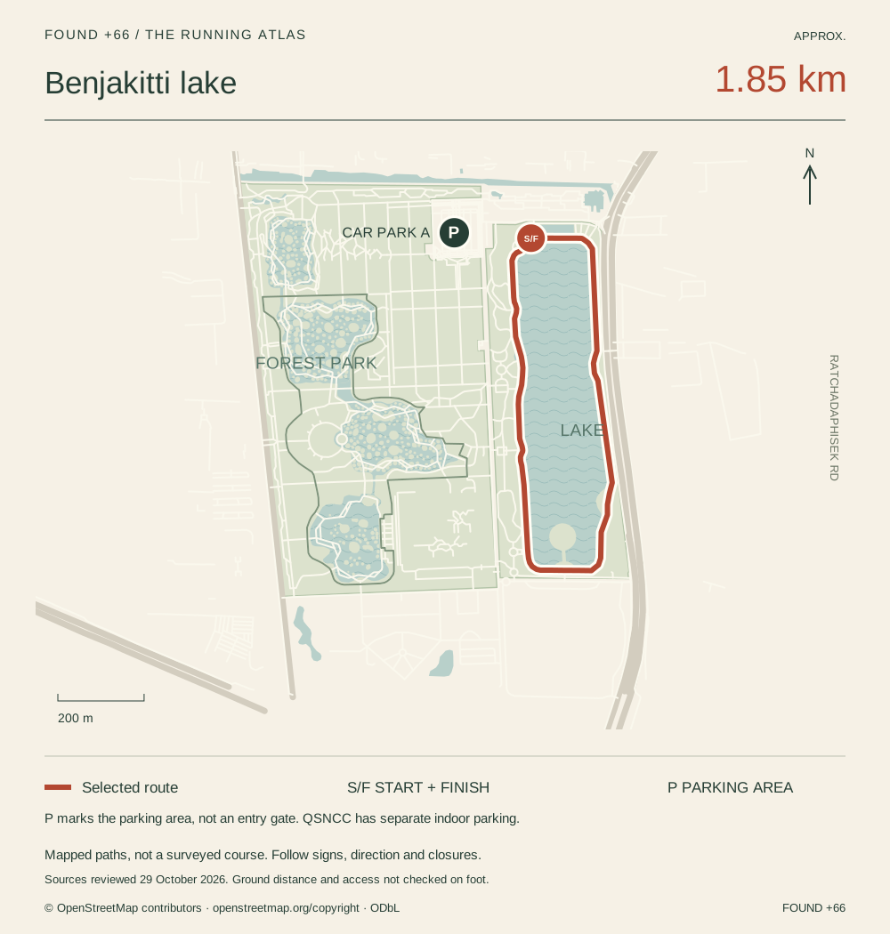
The familiar lakeside circuit is approximately 1.85 km in FOUND’s map. Bangkok Runners describes its lake laps as about 1.9 km, while Great Runs calls the circuit nearly 2 km. Treat these as approximate descriptions, rather than interchangeable measured courses.
Our S/F marker is a reference point on the northwest lakeside path. Join from the entrance that suits you, and follow the running direction signed in the park. Walking from the car or station adds distance.
The forest run and the Big Loop
Bangkok Runners distinguishes a roughly 3 km Forest Park option from a roughly 5 km Big Loop combining park sections. Great Runs also describes a lake-and-outer-path outing. These are the useful route families to know when repeated lake laps begin to feel familiar.
FOUND’s mapped forest circuit is approximately 2.32 km. Our lake-and-forest combination covers 4.78 km, including a short 305 m connecting path walked in each direction. These maps follow connected OpenStreetMap paths; a club’s chosen junctions and starting point may differ. The park’s BMA page separately advertises a 2.8 km running route without supplying its exact line.
Use the designated running paths. The elevated forest skywalk is outside our running plans. Walk shared connections where indicated, and follow closures and staff directions.
Planning 5, 10 or 15 km
A distance goal is a training choice. Choose a circuit you like, then repeat it or add a final section. The planner above gives approximate lake-lap counts for 5, 10 and 15 km without presenting those distances as three different routes. A partial final lap ends away from S/F, so leave time to return to your exit.
For variety, consider the combined park route or the connection to Lumphini. Use your watch for the distance on the day; the map is a guide to the paths, not a measured race course.
A morning through both parks
FOUND’s two-park outing starts at the northwest Benjakitti lake, follows the mapped connection towards Lumphini, circles that park and returns. It is approximately 7.59 km, including a 2.59 km mapped Lumphini circuit. Starting elsewhere or choosing another path changes the total.
Forest and Green Bridge connections include stairs and shared paths. Treat those sections as walking, check access at both ends and allow time for the return. This is a mixed run-and-walk outing, rather than an uninterrupted running course.
Where to park the car
Benjakitti: the park has surface parking, with driving access from Ratchadaphisek Road, according to BMA. Car Park A is marked here. The pin identifies the parking area, not a confirmed entry gate. Follow the parking signs and staff instructions when you arrive.
QSNCC: the convention centre offers separate indoor parking, open 05:00–24:00, with cars on B1 and B2. Check its official driving directions and current parking terms before leaving your car. Charges and validation depend on the current arrangements; a past event’s free-parking offer is not a general tariff.
Special events can change access. General park opening hours do not establish when vehicle gates open, and we have not verified a current park car-gate schedule or parking fee.
Find some company, then take your time
For a social run, Bangkok Runners publishes current outings and Sabai Run Club describes 3 to 4 km runs welcoming beginners and visitors. Check each organiser’s meeting point and latest notice.
Afterwards, our after-the-park guide has ideas for coffee or a meal. A separate Bodytune appointment can fit later in the day.
Sources reviewed 29 October 2026. Route families are supported by public running guides and club descriptions, not a Strava popularity ranking. Maps use attributed OpenStreetMap geometry; FOUND has not measured these courses on foot. Distances, access and parking arrangements should be checked on the day.